
報告者:盛宜楠
報告PPT:M2-Hospital
作品名稱:M2 HOSPITAL
作品作者:Forensic Architecture(UK)
作品來源:Ars Electronica Hybrid Art(2017)- Honorary Mention , Forensic Architecture
作品說明:
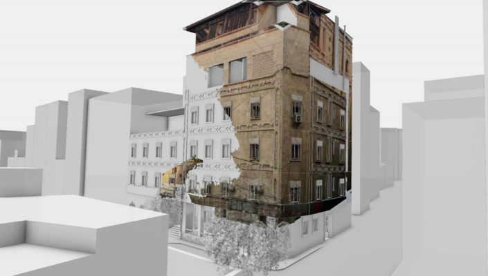
According to the Syrian American Medical Society, the Omar Bin Abdul Aziz Hospital, also known as M2, was subject to 14 strikes by pro-government forces from June to December 2016. The strikes were predominantly carried out by air to surface missiles, but also included illegal cluster munitions, barrel bombs, naval mines, and artillery. The hospital sustained significant damage over this period, which rendered it out of service several times. According to the UN, M2 Hospital was one of only three hospitals left in Aleppo by mid-August 2016 offering intensive care facilities and the only hospital with a pediatric department.
Photographs and videos taken in and around the hospital facilitated our analysis of the consequences of these strikes. Each piece of footage captured only a small part of the building; however, by combining and cross-referencing these clips we were able to reconstruct the building as a 3D model and locate the exact sites of the bombings and the resultant damage. This model became the medium through which we could navigate between various images and videos of the incidents. Using animation camera paths created to mimic movement through the building while pausing at places of evidence, we were able to elucidate a cohesive narrative of destruction.
There are a number of CCTV cameras in the hospital that are continuously on, capturing every strike. We located each camera and its orientation in the building in order to integrate footage from the CCTV cameras, handheld videos, and photographs within virtual space, creating a tangible connection between these media and verifying their position in relation to each other. One particular video showing workers moving from the inside to the outside of the building was essential in geolocating the hospital, as it revealed a common characteristic of the built environment seen in satellite imagery. The spatial link created as a result allowed us to anchor all footage to this exact location and to corroborate the range and multiplicity of the strikes, raising questions about the intent behind this destructive pattern of events.
As contemporary conflicts increasingly take place within urban areas, homes and neighborhoods become targets and most civilian casualties occur within cities and buildings. Urban battlefields have become dense data and media environments – saturated with people willing and able to use their cameras to document what’s happening around them. Many violations, undertaken within cities and buildings, are now caught on camera and are made available almost instantly. The growing number of primary sources has dramatically expanded the visual field but has not necessarily added clarity. Images are not self-explanatory, and are often embroiled in secondary conflicts about authenticity and interpretation. Thus a new practice of verification, geo-location, and synchronization is necessary.
Forensic Architecture is premised on the idea that the analysis of human rights violations must involve this kind of modelling of dynamic events as they unfold in space and time by creating navigable 3D models of environments undergoing conflict, as well as filmic animations and interactive cartographies on the urban or architectural scale. In doing so, the very tools architects use to design buildings can also be used to reverse-engineer the reasons for and modes of their destruction. This approach not only allows us to reverse the direction of the forensic gaze and to turn it back on those very state agencies that use forensics to govern or control civilians in the first place, but also to present information in a convincing, precise, and accessible manner that is crucial for the pursuit of accountability.
Links: